Cooley Peninsula Greenway
- Orwell Wheelers
- Sep 18, 2025
- 6 min read

By John McE
Searching for Greenways on the Cooley Peninsula
I had the pleasure of riding on the Cooley Peninsula Greenway recently, a few days prior to the official opening of the latest section. The only dampener was, well, the damp, as the weather was atrocious on the day with strong winds and monsoon-style rain. Nonetheless, it’s a brilliant area, with beautiful routes, and I’m keen to explore further.
My journey started at Strandfield House, possibly the best café in Ireland, where I had the good fortune of bumping into the legendary Micky Harte, so I figured it would be a good day regardless of whether I won or lost.
The first part of the route is the least interesting section, as it is on the busy R173 through Ballymascanlon Resort, Lordship and the Cooley Distillery. The greenway has not been extended on this part of the route (more on that later!) and the road was full of lorries heading further north, as well as to the ferry terminal at Greenore.
I left the main road just before Grange and went cross country past Lily Finnegan’s Pub (Rob Kearney’s ‘local’ apparently) to the coast road at Whitestown Beach. Sadly Lily’s wasn’t open yet. If it was, I might have spent the day in there sheltering from the wind and rain.

The 5km coastal stretch from Whitestown to Greenore is simply AMAZING. The road literally hugs the coast, has minimal traffic, and is totally wild. The poor weather actually added to the experience with sea spray, and even seaweed being blown onto the road. Some stretches had big clumps of seaweed covering the surface.

From that point on, I saw hardly any traffic for the rest of the day. The stretch from Greenore to Carlingford is via the R176, which also hugs the coast and had very little traffic (though no seaweed!).
Carlingford village itself is a well-known gem, boasting a majestic location, a 12th century castle, the historic harbour, lots of pubs and a popular adventure centre. In fact, it is set to become even better, thanks to the recently announced multi-million euro regeneration project.
The new greenway starts in Carlingford Marina, and it is superb – running right on the shore as much as possible. There are a couple of places where the route has to go around some existing dwellings – including 1 home in Drummullagh which sported a giant TRUMP flag. Though, in the main, every effort has been made to stay close to the water. The surface is top class and the junctions are clearly marked.

In theory, the views should be terrific, though sadly, a deluge accompanied me for much of this stretch, and I couldn’t even make out the Mourne Mountains, which were less than 3km away on the other side of Carlingford Lough.
At Omeath, the Lough narrows into the Newry River, and Warrenpoint eventually comes into view on the other side, while the greenway continues to hug the shore. A little further along, work is well advanced on the long-awaited Narrow Water Bridge, which should help integrate the entire Carlingford Lough region, and will certainly make it easier for Orwell Cyclists to reach the magical Mourne Mountains!
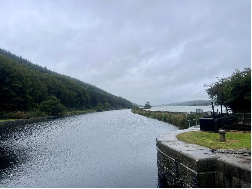
Soon after, I crossed into Co Armagh, and a cool “metal grille section” of the greenway, right on top of the water, before a gravel trail along the so-called ‘Fathom Line’ brought me to the impressive Victoria Lock, which marked the start (or end) of the old Newry Ship Canal. From here, the greenway sits on top of a levee built to contain the old canal. While this looks great, and I would love to try it, the surface is very gravelly - and not suitable for a road bike – particularly in such poor weather.
Therefore, I abandoned my plan to visit Newry and took the ‘Fathom Line’ road for another couple of kms before taking on the extraordinary Flagstaff Hill which, at 25%, is possibly the steepest hill in the country. From there, I took the aptly named “Windy Road” over some more hills and the railway line to join the B113 near Cloughoge.
The B113 is extraordinary. Prior to construction of the modern A1/N1 highway, it was the main thoroughfare linking Dublin and Belfast. Travelling the route today, you might wonder if you had gone back in time, as it is full of curiosities. In just a 5km stretch, I passed several fireworks factories (!), a number of abandoned petrol stations, signs for money changers offering Irish Punts (IR£), enormous “Tiocfaidh Ár Lá” posters, and even an old customs post. Fascinating.
Just before Dromad, the route crosses back into Co Louth and it feels like 2025 again. At this point, the N1 highway runs through a narrow valley, though there is a super 4km greenway running alongside it. Once the valley widens out, the route then passes through leafy Ravensdale and a bunch of other well-heeled villages before returning to Strandfield via Ballymascanlon.
On a better day, this route can be extended in all sorts of ways by taking in Newry, Camlough, Killeavy and the Ring of Gullion.
Returning to the initial stretch of the route, namely the busy R173 on the west and south of the peninsula, this is an area noted for a preponderance of enormous homes, many of which are recently built, and with dozens more under construction. There is a “Hill of Howth” feel in many parts.

At the time of writing, Louth Co Council are striving to build a greenway in this area. They characterize the existing route as having “high vehicle speeds, narrow road widths and lack of segregated facilities which make the road network unattractive for pedestrians and cyclists”. I can only agree.
In response, the wealthy local landowners are fiercely protesting this development and have erected several large signs with COOLEY SAYS NO written in bold red text on their farms, and in front of their McMansions. For a minute I thought I must have crossed the border, as the signs bear an uncanny resemblance to the famous “Ulster Says No” banners, once beloved by some members of the unionist community.

Given the rain, I had the opportunity to duck into a local hostelry in Carlingford, where I managed to speak to locals with diverse views on the proposed greenway - including proponents, opponents and “don’t knows”.
As a cyclist I am obviously biased, though following 90 mins of engaging conversations, it is very difficult to have sympathy for the wealthy landowners. Their true slogan appears to be “The Wealthy Landowning Community in … COOLEY SAYS NO … to poor people, average people, cyclists, tourists, small businesses, change and outsiders”. And even that is being charitable.

Having seen the success of the existing greenway, which respects farming access, brings joy to thousands, and brings business to Cooley, it’s difficult to stomach a straightforward “Ulster Says No”-style campaign, particularly when such signs are plastered in front of enormous homes and on the edge of ranch-style farms.
Many locals are suspicious regarding more nefarious motives for the vociferous objections. This is due to the situation regarding adverse possession (squatters rights) in the area. It’s seemingly an open secret that local farmers have occupied chunks of state land adjacent to their farms, planting trees and putting up fences to try and assert possession. They now see the greenway as the state’s attempt to reassert ownership (or retain ownership) of these lands, thereby denying the farmers their expected windfalls from adverse possession.
Remarkably (!) farming groups neglect to mention this when outlining their objections, which reads like a laundry list of why no one should build anything anywhere.
I wish the poor County Council well in their endeavours to proceed with this. Consultation is on-going and they have proposed several possible routes in order to assuage genuine concerns and find a workable compromise. Hopefully cycling organisations can also make our voices heard in favour of this project. It would help make an already good cycling area into a great one!


Comments